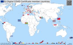
EU Digital COVID Certificate usage in the World
Saturday, January 22. 2022
Comments
Display comments as
(Linear | Threaded)
Add Comment
In my previous post, I gave some statistics about which countries have issued how many X.509 certificates for signing the COVID Certificates. Also, I realized how adoption of this open-source system in non-EU -countries is wide. Actually in the list of countries using the system, there are more non-EU -countries than EU-countries.
As I wanted to learn how to progammatically alter SVG-files (they are essentially XML), I decided to write some code. Here is the result:

Updated map is available at https://blog.hqcodeshop.fi/vacdec-map/, also in SVG-format. Source code of how all this is created is at: https://github.com/HQJaTu/vacdec-map
The process begins with importing maps of the World from Wikipedia page Gallery of sovereign state flags (using Wikipedia API, of course). There is one shortcoming, Faroe Islands map isn't in the list as it is not a sovereign state. It is downloaded separately.
Then the flags are mapped against ISO-3166 country list. Again, some manual helping is needed, list of flags doesn't use all of the exact country names from ISO-standard. Good thing about this is, the need to do this only once. Flags and countries don't change that often.
Fetching the X.509 certificates for signing is something my code has successfully done since August -21. So, a list of known COVID Certificate signing certificates is fetched. A simple iteration is done to those X.509 certificates to find out the oldest date of any country. That date is assumed to be the system adoption date. In reality it is not, but for this coarse visualisation that accuracy will do.
Now there is a repository of all the flags with their appropriate ISO-3166-2 codes and all COVID signing certificates with their issuing dates. Then all country flags are placed on top of a World map, which has a second part in the bottom, a timeline for adoption date for non-EU -countries. Drawing EU-countries there is non-interesting as they pretty much did it all at the same time. The map SVG comes from Wikimedia Commons Carte du monde vierge (Allemagnes séparées).svg.
For optional PNG-rendering, I'm using Inkscape. There are failing attempts to do SVG-rendering with CairoSVG, PyVips and Html2Image. First two failed on accuracy, the rendering result was missing parts, had incorrect scales on various parts and was generally of low quality. Html2Image kinda worked, but wasn't applicable to be run on a server.
| Mon | Tue | Wed | Thu | Fri | Sat | Sun |
|---|---|---|---|---|---|---|
| ← Back | February '26 | |||||
| 1 | ||||||
| 2 | 3 | 4 | 5 | 6 | 7 | 8 |
| 9 | 10 | 11 | 12 | 13 | 14 | 15 |
| 16 | 17 | 18 | 19 | 20 | 21 | 22 |
| 23 | 24 | 25 | 26 | 27 | 28 | |